Project description
Ready2BIM (Planning of the renovation of residential buildings and adaption into the BIM workflow) is a project funded in the EUREKA framework under the grant number 2018-2.1.3-EUREKA-2018-00032. The goal is to develop an innovative toolset for refurbishment project in building and district retrofit assessments and planning, combining the potential of Building Information Modelling (BIM) by allowing architects and planners work on multiple scales and on multiple buildings and districts.
Participants:
Geonardo Environmental Technologies Ltd,, 7 Zahony Street, H-1031 Budapest, Hungary, contact: Péter Gyuris
CAALA GmbH, Sonnenblickstr. 9, 81377 Munich, Germany represented by the Managing Director, Philipp Hollberg
SZTAKI (Institute for Computer Science and Control, Eötvös Loránd Research Network, Hungary), 13-17 Kende street, H-1111 Budapest, Hungary, contact: Dr. Csaba Benedek
Project duration: 2020-01-01-2021-12-31
Total budget: €159,000
Project goals, mission statement
The European building stock needs fast and affordable digitalization for facilitating the renovation process to achieve higher energy efficiency in buildings and in houses. Most of the residential buildings built between 1925-1975 lack proper documentation and digital building information, as opposed to newer buildings. Digital building information (geometry and attribute data) is required to plan retrofitting projects or renovations of facades. This work can only be efficient if Building Information Modelling (BIM) is available for stakeholders (owners, architects, contractors etc.). Whereas city planners of municipalities or social housing companies are striving to manage their properties and building portfolio on multiple scales. These stakeholders are seeking an approach that enables spatial planning, efficient asset management and energy consumption and management services for their buildings. In a EUREKA labelled project (E!12649 Ready2BIM) three partners worked together, two from Hungary (Geonardo Ltd. and SZTAKI) and one from Germany (CAALA GmbH).
Status and main achievements of the project
News: The Ready2BIM project has been successfully finished on 31. December 2021.
The project was based on the following main development phases:
At the beginning all the necessary definitions and baseline research for the architecture of the new online-platform has been defined and developed: The architecture of the new online-platform, which defines all the interoperability requirements of the different modules and how these modules (e.g. FASUDIR prototype and the CAALA tool) can be connected to each other and work together. Also the new modules for smart algorithms for 3D-model creation on building level was planned and connected in order to allow the BIM process in the tool to run on building level. Moreover, the necessary data requirements for the interaction of all software modules and data formats are defined (data sources, levels of-detail, scales, etc.)
The online platform was further developed to accommodate multiple types of building information such as architectural data e.g. drawings, CAD/IFC and standard 3D file formats. Also attribute information such as building type, construction year, billing information was to be incorporated; all that is important to plan retrofitting projects with cost calculation and return on invest. All necessary default databases have been defined and set up.
In Phase 2 the implementation and programming of the new online-platform was to be conducted: The interfaces for the connection of the different data formats and existing modules (FASUDIR prototype, CAALA tool, 3d modelling algorithms, etc.) was to be set up and integrated in the online platform back-end. All the external services (e.g., Web-GIS server, open data sources, APIs) planned to be connected to the online platform. A user-friendly and graphical user-interface based on a 3D-map was planned to allow the users a quick and easy interaction with the online-platform.
Online demonstartor
As part of the online platform, a new, browser independent application has been developed in order to measure and analyze facade elements of buildings. In the application point clouds of the facades can be uploaded, and various measurements can be applied that can help place insulation elements on them.
The main features of the application are:
• Supports point clouds in PCD, LAS / LAZ or XYZ format.
• Point cloud visualization in 3D.
• Navigation: rotating, moving, zoom.
• Automatic alignment of planes, separation of roof and side walls, marked with different colors.
• Detection of protrusions and outliers of planes (e.g. cornice, window frame, etc.).
• Selecting one or multiple planes by user interaction.
• Automatic tiling of selected planes, i.e. splitting them into rectangles or squares with the specified side length.
• Creating and displaying a vector model from the results of tiling.
• Numerical evaluation of tiling results (number of tiles, size of area covered, etc.).
• Exporting the obtained results, point clouds and vector model.
• The application should run in a desktop browser with mouse, as well as in the browser of a mobile device with touch screen.
Demonstrator program for trial
The online demonstrator program can be accessed from this link.
For testing, a sample point cloud in PCD format can be downloaded here.
Demos of scientific results

Participants
Participants in the project:
Geonardo (coordinator of the project) is an engineering and consultancy company providing cutting-edge solutions in the energy, environment and sustainable development fields. Since its establishment in 1999, Geonardo has become a leading SME in Central Eastern Europe with extensive experience in conceiving and implementing research and innovation projects, predominantly within the framework EU R&I programmes. Geonardo provides technical consulting services specialised in resource efficiency, raw materials, renewable energy sources and energy efficiency applications, conducts feasibility studies and impact assessments, and develops and implements innovative training, capacity building, and dissemination and exploitation actions to bring innovative research results to market.
CAALA GmbH was founded in 2016 as a spin-off of the Bauhaus University Weimar and develops and distributes a unique software for parametric life cycle analysis (PLCA®) of buildings in the early design phase. CAALA's main goal is to foster energy- & resource-efficient building design via digitalization.
The special team constellation of civil engineers, experts for LCA, architects, energy consultants and software developers enables innovation at the interface of architecture and sustainability. Therefore, the foundation was made possible by the Exist Scholarship of the BMWi. In addition, CAALA was supported by Climate-KIC and H2020 SME Phase 1. As an innovative start-up, CAALA has received awards from the DGNB, dena and the BMWi, among others.
The basic idea of parametric life cycle analysis was developed in the context of a doctoral thesis at the Bauhaus University Weimar and deepened in a future building project (ILCO). In addition, one of the founders is conducting parallel research in the field of BIM-based life cycle analysis at ETH Zurich, is a member of the DGNB's expert committee and, by participating in the IEA EBC Annex72, is in close contact with leading scientists in the field of life cycle assessment of buildings.
The CAALA cloud-based software toolset offers real-time assessments of building designs with regard to the environmental and economic life-cycle performance, the energy demand as well as German energy regulations. The software connects via plugins with a number of different CAD/BIM tools. The CAALA software has more than 800 registered users and is used at 10 universities as well as by several architecture associations.
SZTAKI (Institute for Computer Science and Control) is a research institute. Its staff consists of more than 300 full-time employees, more than 200 with university diploma and more than 70 with scientific degrees. The Institute is very active in graduate and postgraduate education, co-operating with most technical universities in Hungary and operating common chairs, postgraduate programs with them. More than 40 members of the Institute’s researchers conduct regular lectures/classes at graduate and postgraduate levels, and senior researchers hold part-time positions as university professors. 20-30 Ph.D. students and 20-30 graduate students participate in the work of the Institute. The Institute has wide external relationships in its R&D profile. ERCIM (European Research Consortium of Informatics and Mathematics) granted full membership to the Institute in 1994. The Institute is a member of the (World Wide Web) W3 Consortium led by the Massachusetts Institute of Technology (MIT) and of other international organizations. Our Institute won the title of "Centre of Excellence" of the EU, and the number of EU projects is also impressing.
SZTAKI’s project participation is conducted through the Machine Perception research laboratory (MPLab). The goal of MPLab is the interpretation and organization of information coming from distributed multimodal sensors. Sensors can be dynamic or static imaging devices or other multimedia sources. By spatio-temporal analysis of information we recognize and classify events. These events are e.g. unusual motion patterns, behaviour change in time series, voice patterns. We place special emphasis on machine learning, data mining, human perception, geometrical optics, multimodal sensor fusion, optimization methods and variational analysis in areas such as image and video processing, biometrical identification, connections with sensor networks, Geographical Information Systems, and computer graphics.
Publications
Publications from the project activites:
Note: acknowlegement for the project is in each paper.
P. Gyuris, B. Pal, Cs. Benedek, Zs. Janko, ”Collaborative research and innovation project for revitalizing the BIM process", e-Zbonik: Electronic collection of papers of the Faculty of Civil Engineering, vol. 11, no. 22, December 2021 ![]() Open Access
Open Access
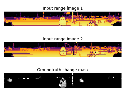
B. Nagy, L. Kovács and Cs. Benedek: ”ChangeGAN: A deep network for change detection in coarsely registered
point clouds,” IEEE Robotics and Automation Letters, vol. 6, no. 4, pp. 8277 - 8284, 2021, IF: 3.741 ![]() Open Access
Open Access
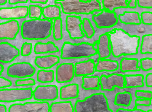
Y. Ibrahim, B. Nagy and Cs. Benedek: ”Deep Learning-based Masonry Wall Image analysis,” Remote Sensing, vol. 12, no. 23, article 3918, 2020, IF: 4.848 ![]() Open Access
Open Access
S. Taoufiq, B. Nagy and Cs. Benedek: ”HierarchyNet: Hierarchical CNN-based Urban Building Classification,” Remote Sensing, vol. 12, no. 22, article 3794, 2020, IF: 4.848 ![]() Open Access
Open Access
Y. Ibrahim, B. Nagy and Cs. Benedek: "A GAN-based Blind Inpainting Method for Masonry Wall Images", International Conference on Pattern Recognition (ICPR), Milan, Italy (virtual conference), 10-15 January 2021 ![]()