 |
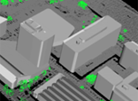
Building facade reconstruction from Velodyne point cloud streams: based on our intelligent mobile mapping system, we create geometrically reconstructed and textured 3D scene models, visualise various building facades and landmarks
|
|
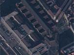
Virtual city reconstruction based on aerial Lidar measurement. Test data provided by Airbus Defense and Space Hungary Ltd. |
|
Texturing an airborne Lidar based mesh with Pleiades satellite photos: an automatic texturing approach has been proposed utiliting the geo-referred data |
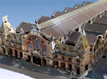 |
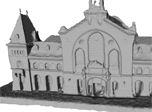
Dynamic virtual city modeling: complete 3D reconstruction flow of the Great Market Hall, Budapest, and displaying a dynamic scenario with multiple pedestrians in front of the building |
|
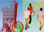
Mixed reality: pedestrian models from the 4D studio walking in large Velodyne point clouds recorded from landmarks of Budapest, Hungary: Klotild Palace, Budapest University of Technology and Economics and Kalvin square.
|
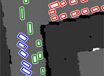 |
Remote sensing: airborne Lidar data segmentation and automatic traffic monitoring: we automatically detect parking and moving vehicles in aerial LIDAR point clouds, and identify groups of corresponding vehicles, such as cars in a parking lot, or a vehicle queue waiting in front of a traffic light. |